![]() 18 September 2025
18 September 2025
SWIFTT will provide affordable, simple, and effective remote sensing tools to monitor forests at risk across Europe, using Copernicus Sentinel satellite imagery and powerful machine-learning models, allowing forest managers to prevent, estimate and mitigate the impact of windthrow, insect outbreaks, and wildfires.
The calibration of those models depends on ground-truth data used as training material. For that reason, SWIFTT has partnered up with forestry companies Forestry Europe, EcoTree International, Arco-Zinneberg, and Alcina Forêts to collect precise, time-stamped and geo-referenced data sets on bark beetle, wind, and fire damage in their forests, as well as identifying areas with healthy, intact trees. This will help train the SWIFTT models to distinguish between damaged and undamaged forests.
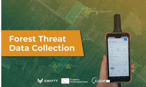
This second phase of data collection for SWIFTT started early summer 2025 and will continue until the end of October 2025. It is being carried out using the mobile app developed by project partner Timbtrack.
Once collected, this information is synchronized with the web platform, where it can be reviewed, edited, and enriched with new observations. The dataset is then delivered to researchers, who use it to train machine learning models in order to accurately detect and analyze sanitary threats in European forests.
By connecting field expertise with advanced data-driven tools, SWIFTT brings forestry practice and research closer together, helping foresters and scientists work together for healthier, more sustainable forests.
If you are interested in joining the data collection campaign using the SWIFTT app to send us data from your forest, please get in touch with the SWIFTT team in the link below.

